Deep Creek Lake Tributary Bioassessment
Deep Creek Lake Tributary Bioassessment
Background
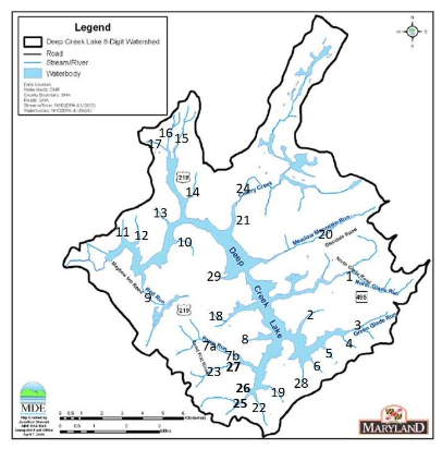
In July 2022, the Deep Creek Watershed Foundation contracted a team from PennWest – California to conduct a synoptic bioassessment of 29 perennial Deep Creek Lake tributaries at sites selected by the Deep Creek Watershed Foundation. Overall, results described cool water streams that exhibit measurable total alkalinity and generally possess good chemical water quality. However, sediment buildup on stream bottoms resulted in lower than expected macroinvertebrate and fish abundance.
In July 2025, the Foundation contracted the same team from PennWest – California to conduct another synoptic bioassessment of the same 29 tributaries, and one additional location, to better understand how tributary water quality and habitat has changed over time at Deep Creek Lake. The total contract amount for the 2022 and 2025 study work was $27,725, and was funded via private donations to the Foundation. This effort partially fulfills Goal 3 of the Deep Creek Watershed Management Plan.
Purpose
The 2022 study served as a preliminary baseline of tributary water quality and habitat. This study assisted the Foundation in identifying potential projects that help to preserve and protect the watershed over the last three years. The 2025 tributary study provides updated data that can be compared to the data collected in 2022, and other previous data collection efforts, to better understand how water quality and habitat in the tributaries surrounding Deep Creek Lake have changed over time.
Key Takeaways
- Water quality within the tributaries sampled is generally good with approximately neutral pH and Total Dissolved Solids (TDS) concentrations well below 500 ppm, the acceptable limit for drinking water.
- 360 fish were collected from 15 different species, across 21 of the 30 tributaries sampled. These fish were primarily Blacknose Dace, Creek Chub, and Yellow Bullhead. Brook Trout (Smith Run), Muskellunge, Largemouth Bass, Yellow Perch, and Walleye were also among the fish assessed. Fish diversity and abundance increased between the 2022 and 2025 study.
- During macroinvertebrate sampling, 546 individuals from 32 taxa were collected across 21 stations. Crayfish were the most commonly collected macroinvertebrate.
- While chemical water quality is generally good and supports aquatic life, macroinvertebrate and fish aquatic habitat continue to be poorly impacted by the buildup of sediment on the streambank floor, potentially related to human impacts such as residential and commercial building.
Next Steps
The Foundation has shared the tributary study reports with Maryland Department of Natural Resources, Maryland Department of the Environment, and the Garrett County Public Health Department for their awareness and potential use. The Foundation will continue to perform future tributary studies to track water quality and habitat changes over time. The Foundation will continue to work to identify potential projects based on the results of the 2025 report.
Tributary Sampling Locations

Tributary Reports & Resources


