Lake Water Level Management Tool

Lake Water Level Management Tool

Recently Brookfield Renewable Energy gave a presentation to the stakeholders that included a very informative sharing of the difficulties involved in managing the water levels in Deep Creek Lake.

The Deep Creek Watershed Foundation has been working since its creation to create a management tool to equitably allocate the use of the water in Deep Creek Lake to generate power. Brookfield’s success in managing the resource affects all stakeholders. The management must be carried out within the framework of the Water Appropriation Permit administered by the Maryland Department of the Environment.

The company is required to submit an annual report. For those with time on their hands, you can find the reports at: https://mde.maryland.gov/programs/water/water_supply/pages/deepcreeklakeperiodicreports.aspx. The reports are complete and afford a wealth of data about the power generation operation.

Century Engineering from Baltimore completed the first Water Budget Model for the foundation in June of 2018. Because there was no record of watershed rainfall, no record of water levels, and no record of discharge until two months after the end of the calendar year, a traditional water budget model could not be constructed. They produced a bookkeeping scheme that used the water remaining above the Lower Rule Band on a particular day and subtracted the daily required releases going forward until that water was consumed. When a rainfall event occurs, the lake level goes up and the end of the water day moves forward in time. The foundation distributed that model to the power company.

Starting in 2018, the foundation set to work to provide the necessary data to complete a traditional water budget model. We worked with the United States Geologic Survey to augment the gauges in the watershed area that were in place.

The first one was a recording water level gauge for the lake. Lake management is predicated on the water level relative to the overflow weir at the power company dam, which is assumed to be at elevation 2462. The national level grid is about 1.8 feet different, so we asked USGS to record both datums in the data set. The significant advantage of using them is that the record is kept on the Internet and available to everyone. Given the difference between the elevation measured by survey methods and the staff gauge at the dam, the staff gauge is a single point of failure for managing lake levels according to the permit. The USGS gauge has records back to August 2020.

The foundation sponsored two additional rain measurements to augment the USGS rainfall records at North Glade Run, one at Cherry Creek and the other at Hoyes Run.

The USGS flow gauge on the Youghiogheny River immediately downriver from the power plant discharge has been operating since July 2011. The flow data shows the base flow of the river and the discharges from the power plant. A second USGS gauge was installed upstream at Swallow Falls to evaluate the base flow.

In May 2022, the foundation contacted CEC, a civil and environmental engineer from Pittsburgh, Pennsylvania, to complete the traditional water budget model. The fundamental idea of the water budget model is Water In – Water Out = Change in lake level. With the additional rainfall measurements, the record of water levels, and the record of discharge from the plant for the water year from 1 October 2023 to 30 September 2024, CEC can ascertain the dynamics of the fundamental idea. The goal is to create a model that considers past rainfall, current lake level, and future discharge to produce power per the permit.

Consider an old, clawfoot bathtub full of sand and gravel. Below the drain, attach a recording flow gauge. Water poured into the tub will flow out at a rate and duration based on the amount of water. A record of flow vs. time for one five-gallon bucket dose, a ten-gallon dose, and enough water added to reach the top of the tub plotted on a discharge vs. time graph would calibrate the tub and its contents to predict the rate water will come out of the drain.

The Deep Creek drainage area is like the bathtub. Water runs off, evaporates, and soaks into the ground when it rains. Twelve hours after a rain, all precipitation has run off into the lake or streams. The water that soaks into the ground flows by gravity. Consider the water level in a water supply well. That level is where the groundwater surface is. Most of the water supply wells around the lake have a level higher than the lake, and groundwater flows into the lake. All the lake’s water comes from direct rain, stream flow, or groundwater recharge. An analysis of precipitation records, lake levels, and lake discharges could model the recharge of the lake based on past rainfall.

To be useful to the power plant operator, CEC is creating an Operator User Interface (OUI). The OUI will consist of a computer program that operates behind the scenes to query the USGS websites to retrieve inputs on past rainfall, current water levels, and permitted requirements for discharge. The primary challenge is to model the recharge into the lake from groundwater. The engineer will use the USGS rainfall, flow and water level data collected from October 2023-September 2024 to create the water budget model recharge component.

The OUI works using the same bookkeeping technique as the original limited model. On a given day, the operator enters the date. The program returns the remaining days before the water level goes below the lower rule band. Given the advance notice of the limited water supply, The Maryland Department of the Environment and the plant operator could devise a plan to distribute the remaining available water among the stakeholders equitably.

The plan to deal with the water shortage will make it less of a problem for the various interests in the water in Deep Creek Lake if MDE and the power company put it in place before the need for it!

CEC has a year record and is preparing the OUI now.

2024 Rainfall is up but still a Drought

2024 Rainfall is up but still a Drought

There were ten more inches of rainfall this water year than last year.  The reason for the apparent drought was the rainfall distribution. The graph and supporting data below show that the situation started to develop in April of 2024 when the precipitation fell off.

By April 2024, the watershed had received as much rainfall as it had by September of the previous year. The groundwater recharge relationship incorporated in the completed water budget model will allow the vagaries of rainfall to be accounted for by the mass balance of water in minus water out equals the change in water level. This approach allows the analysis to avoid needing to model such things as evaporation, transpiration, hydraulic transmissivity, etc.

The goal is to model how rainfall moves through the system to allow for a robust predictive model.

The rainfall distribution study for 2022-2023 vs. 2023-2024 at Deep Creek is below. 

2022-23 vs 2023-24 Rainfall

DCWF Receives Grant from the Community Trust Foundation

The Deep Creek Watershed Foundation received a grant from the Community Trust Foundation to help fund a free rain barrel distribution event in Garrett County. Through the generosity of community donors to the Foundation there are going to be one hundred free 50-gallon rain barrels given to participants. The only stipulation is that you attend a free class through University of Maryland Extension to learn more about maintaining and using the barrel. Classes are planned for late June.

A rain barrel is a container that is used to capture rainwater to help mitigate stormwater. The water can then be used for non-potable tasks such as washing vehicles or watering ornamental gardens/lawns. The goal is to slow down the water and let it soak into the ground after the rain event. If you are interested in earning a free rain barrel, please contact Ashley (email abachtel@umd.edu or call 301-334-6960) with University of Maryland Extension.

For more information on the benefits and approach for rain barrels, please click here to access our Rain Barrel Fact Sheet.

NEW! Groundwater Recharge and Completion of the Water Budget Model

The completion of the water budget model (WBM) is in response to Goal One and Goal Twelve of the Deep Creek Watershed Management Plan (WMP). The water budget model (WBM) will help predict water levels based on measured and estimated inflows, which would in turn will improve the decision process for the timing and volume of Deep Creek Watershed Management Plan water releases. Currently, the model created by the Foundation relies on a bookkeeping scheme that keeps track of the required releases and the water remaining in the pool. It is advantageous because it is updated daily, and a daily prediction is made of the number of days remaining until the lower rule band is reached. The first step in the journey to a completed water budget model was the installation by USGS and financed by the Foundation of a recording water level and water temperature gauge near Meadow Mountain Run. The output from this gauge as well as lake water temperature is recorded every fifteen minutes on a data retrievable website. The gauge serves as a backup to the gauge that the power plant operator maintains as a part of the water appropriation permit. The power plant data record is unavailable on the internet except for daily levels and other data. The Foundation paid $15,310 to USGS for this installation. The gauge data will show how the water that comes into the lake affects the water levels when combined with rainfall and discharge records. Two more continuously recording precipitation gauges in the watershed to augment the precipitation gauge at North Glade Run and discharge records available in real-time from the power plant will afford the data to construct a groundwater recharge model for the lake basin. Using the same bookkeeping technique, the recharge model will extend the predictable lake levels from days to months. We have added precipitation recording capability to the existing Hoyes Run USGS flow gauge on the Youghiogheny River and at the existing USGS flow gauge at Cherry Creek. The recorded precipitation data added to the longer precipitation record from the North Glade Run precipitation gauge will afford better precipitation records for the watershed. There are long term USGS precipitation records available from the gauge at Oakland on the Youghiogheny River to inspect the correlation. USGS has installed a river flow gauge upstream of the Deep Creek nexus with the Youghiogheny River. We refer to this gauge as the Top Yough Gauge. The additional gauge will provide flow data in conjunction with the Hoyes Run gauge. Factoring in the travel time between the gauges, it will be possible to infer the amount of water leaving the watershed. The Property Owners Association donated the capital cost of $21,750 and we have a donation of $17,970 for annual operation and maintenance for the gauge on the river upstream of where Deep Creek joins the Youghiogheny. The completed Water Budget Model will account for the water coming into the lake; the lake level data will show how the lake reacts to the rainfall and how the water coming out of the watershed into the river relates: Water In – Water Out = Change in water level. COMPLETED AND CONTEMPLATED JOINT PROJECTS WITH USGS INCLUDE
  Gauge build and Equipment Purchase Annual Operation and Maintenance Foundation Contribution USGS Match Total Cost
Recording Lake Water Temperature Gauge at State Park $1,200  $3,050  $4,250  $0  $4,250 
Recording Lake Water Level Gauge at State Park $4,800  $6,260  $11,060  $0  $11,060 
Co-located Precipitation Gauge at Hoyes Run $8,155  $4,575  $12,730  $0  $12,730 
Co-located Precipitation Gauge at Cherry Creek $8,155  $4,575  $8,155   $0 $12,730 
Stream Gauge upstream of Brookfield Power in Youghiogheny River $21,750  $18,600  $39,660  $0  $40,350 
The Deep Creek Lake Manager has agreed to pay for the operation and maintenance costs associated with the new Cherry Creek recording precipitation gauge at Cherry Creek and the water temperature gauge. Funds will be required from our Donors to have USGS operate and maintain all these gauges to the tune of $28,735 every year. The WBM completion hinges on the ability to evaluate the simple relationship of Water In minus Water Out equals Change in Water Level…  Easy to say, but gathering the input data will require a precipitation record over the lake recharge area, discharges from Deep Creek and the power plant into the river, and a record of water levels, all retrievable from a USGS digital database. A recent bathymetric survey of Deep Creek Lake by DNR confirmed the Stage-Storage relationship determined when the lake was built by Youghiogheny Hydro-Electric Company in the 1920s. One of the reasons for partnering with USGS is that they record the data they collect, which is readily available in real-time on the internet.  Our long-term goal is to use the water budget model as a basis for a water use management plan. Once the recharge model is incorporated, a predictive capability will afford the Water Appropriation Permit holder under the direction of the Maryland Department of the Environment the ability to equitably allocate the water that comes into Deep Creek Lake. The current appropriation permit requires that the operator use a predictive model to control operation. While the Deep Creek watershed has been blessed with abundant rainfall in recent years, a dry summer will happen. A water level management plan containing provisions for equitable water allocation when and if a shortage occurs will avoid contention between the stakeholders for the resource. A robust water budget model will afford the predictive ability needed to plan for times of low precipitation. For example, Lake Management can inform the lake users that water levels around docks will be lower than normal. The whitewater rafting community can accommodate in advance their release schedules appropriately to the available supply. Fisheries can tailor the temperature enhancement releases to fit the available supply. The power plant will be able to plan how much power it can produce and when. The completed Water Budget Model will make it possible to manage how the lake waters are used to equitably benefit all the stakeholders.
More About

Recharge Report 3 April 2024

Data for Deep Creek Lake was extracted from the USGS websites for Deep Creek Lake levels, precipitation for North Glade Run, Cherry Creek, and Hoyes Run, and the flow in the Youghiogheny River at Hoyes Run.
The data was plotted using Excel and AutoCAD to draft all the parameters in the same drawing. When plotted on letter-sized sheets and assembled into one, the results are over eight feet long… So, the days are plotted individually and included as .pdf documents so that they can be accessed readily.

During periods of rainfall, the precipitation is immediately added to the water level. This is evident on the 10th and 15th of March. The stream flow in the Youghiogheny River reacts later due to the travel time. Incidentally, twelve hours after the end of a rainfall event all of the runoff has occurred. The remainder soaks into the ground and is taken up by evaporation and entering the groundwater table.

The discharge from the power plant is inferred by subtracting the baseflow from the river discharge. From the area under the plant discharge record above, the estimated base flow per unit time indicates the plant discharge. The time of discharge signature is more discrete.

The total estimated power plant discharges for the period total 2,943 Ac-Ft (One acre of water, one foot deep). Using the storage-vs-lake level derived from prior work by the Maryland Geologic Survey and power plant records, the net change in lake storage minus the discharge is 1,662 Ac-Ft. In other words, 2,943 Ac-Ft through the power plant plus the 1,662 Ac-Ft increase in lake level for the period is 4,605 Ac-Ft.

An average of 1.13 inches of water fell on the watershed during that period. Assuming a drainage area of 40,000 acres for the lake and assuming that all of the water entered the lake during the period, 3,767 Ac-Ft would have been added. Arithmetic indicates that at least a thousand acre-feet of more water came into the lake than went out. Note that the lake level on the 22nd was about 0.4 feet, or about 5 inches higher than at the beginning of the period, considering about one inch of rain on the watershed and close to three thousand acre-feet of power generation.

This brief analysis is similar to the work that our consultant CEC will perform over a much longer period of time to measure the influence of groundwater recharge and incorporate it into the completed water budget model.
Respectfully submitted,
Morgan C. France, PE(ret)

Newly Appointed Secretary of DNR Visits Deep Creek Lake

DEEP CREEK LAKE — Newly appointed Secretary of the Department of Natural Resources (DNR), Josh Kurtz, visited Deep Creek Lake on July 26.

This visit included a boat tour of the lake and a buffet at Ace’s Run hosted jointly by the Deep Creek Lake Property Owners Association (POA) and the Deep Creek Watershed Foundation (DCWF).

The agenda of the visit included discussions of projects, plans, and current needs in the area. The success and benefits of past projects, the importance of the wellbeing of the lake and the importance of the relationship between the POA, DCWF, and the DNR were also discussed.

In attendance were State Senator Mike McKay, Garrett County Commissioners Paul Edwards, Ryan Savage, and Larry Tichnell, POA President Bob Sutton, DCWF President Bob Hoffmann, as well as lake and park managers and other POA and DCWF members.

Some of the topics discussed at lunch included the need for more manpower for lake management, park management, and NRP, future funding for the lake, and the successful relationship between DCWF, POA, and the DNR.

“It was a wonderful trip”, says Secretary Kurtz, “I think one thing that stood out to me was how well everybody in this room works together, and I think that’s a testament to the success you see on the lake, and the opportunities for us to continue to do more…I mean the number of people that are investing their money to make the lake better really stood out.”

Senator Mike McKay compared the relationship between the organizations to a three-legged stool.

“As much as we appreciate all the beauty here, it has to be properly managed…if one leg is longer than the others, we’ll fall off the stool so it’s a proper balance,” said McKay.

DCL POA President Bob Sutton said, “We all appreciated Mr. Kurtz taking a day to visit the lake and are looking forward to working with him and his staff in the future!”

Deep Creek Watershed Foundation Recipient of Garrett County of the 2021 William Donald Schaefer Helping People Award

On Saturday morning, October 1, 2022, The Deep Creek Watershed Foundation (DCWF) will be honored as the recipient for Garrett County of the 2021 William Donald Schaefer Helping People Award. This award will be presented to the DCWF by the State of Maryland’s Comptroller, Peter Franchot. More information about this annual award and program can be found at the link below:
https://www.marylandtaxes.gov/divisions/comp/peter-franchot.php#wds
The DCWF is a 501 (c) 3 non-profit organization formed in 2016 and designed to accept tax deductible donations and use those donations over time to support the implementation of the Deep Creek Watershed Management Plan (WMP). The WMP was created in a collaborative effort between citizens of Garrett County, Garrett County Government, and the Maryland State Department of Natural Resources. It was clear to some of those citizens who assisted in the development of the plan, that neither the State nor County would alone be able to fund the myriad of projects necessary to implement the plan. To address this fiscal reality, the DCWF uses a methodology of creating public/private partnerships to fund projects DCWF and the projects if has supported thus far as well as planned for the future can be found on our Projects Page

The DCWF has an all-volunteer Board of Directors as well as a very supportive group of Advisors and Volunteers who assist the board in a wide variety of ways.
Financial support is received from individual donors, event sponsors, and grants, nearly, all of which, is applied to projects. Individuals wishing to donate may go donate via PayPal or forward checks to:

The Deep Creek Watershed Foundation
P.O. Box 376 Oakland, Maryland 21550

Read this article online.

Deep Creek Watershed Foundation Recipient of Garrett County of the 2021 William Donald Shaefer Helping People Award page 1

Deep Creek Watershed Foundation Recipient of Garrett County of the 2021 William Donald Shaefer Helping People Award Page 2

NRCS Agriculture Mapping

Create a Photo Map of Historic Shorelines From NRCS Agriculture Mapping

The time-rate of shoreline changes can be documented by rubber sheeting the photos onto a base map using features visible on the base map and on each sheet as it is brought in. Because of the spatial size of the project, it will need to be done digitally. From the file, the time rate of shoreline change can be documented and evaluated. The project partially fulfills Goal 3 of the Watershed Management Plan.

River Flow Gauge on Youghiogheny River Above Deep Creek Nexus

River Flow Gauge on Youghiogheny River Above Deep Creek Nexus

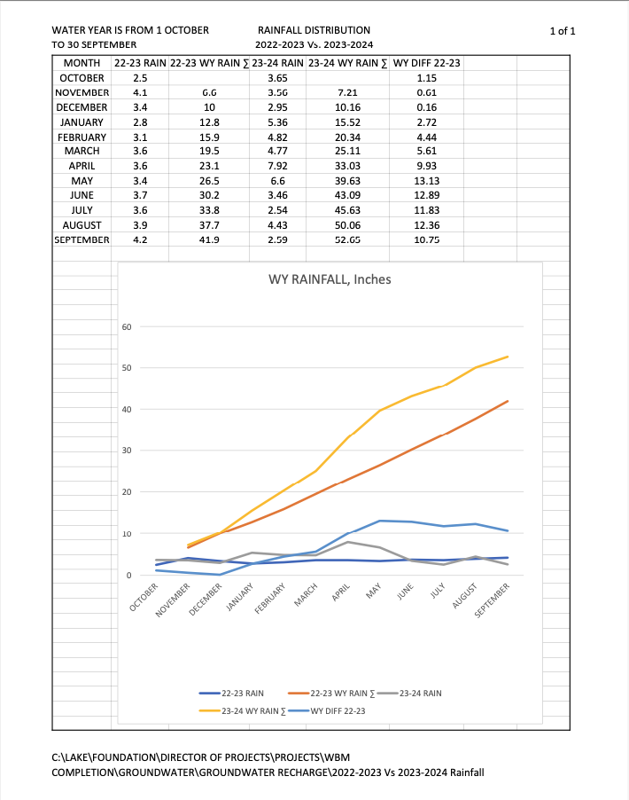
Our next objective is to accrue donor funding of $21,750 in capital costs and a commitment of $17,970 for annual operation and maintenance for the gauge on the river upstream of where Deep Creek joins the Youghiogheny. The existing flows at that point subtracted from the flows measured at the Hoyes Run gauge will indicate the discharges from the Deep Creek watershed, including flows from the power plant and groundwater discharges.

The Completed Water Budget Model will be able to account for precipitation, groundwater recharge, flows through the power plant plus the discharges around the dam, factoring in the discharges required through the power plant by the Water Appropriation Permit. An apparently simple relationship determines the water levels in the lake: Water In – Water Out = Change In Water Level.

A recent bathymetric survey of Deep Creek Lake confirmed the Stage-Storage relationship determined when the lake was built by Youghiogheny Hydro-Electric Company. The project partially fulfills Goal 1 of the Watershed Management Plan.

The new USGS flow gauge upstream of the Swallow Falls Bridge on the Youghiogheny River will measure the river flows upstream of the power plant. The difference in flows, adjusted for travel time, will afford an indication of the discharges from the Deep Creek Watershed.

The discharge from the watershed (Water Out) is a component in the analysis of the groundwater recharge and the precipitation (Water In). The other component is a record of lake water levels.The public doing recreational boating and swimming in the river reach from Swallow Falls to the Sang Run Bridge will be safer because the river flow rate is conveniently available on the USGS
website.

Do you have questions? Call or visit us.

(703) 975-8485

P.O. Box 376
Oakland, MD 21550

Newsletter


By submitting this form, you are consenting to receive marketing emails from: DCWF. You can revoke your consent to receive emails at any time by using the SafeUnsubscribe® link, found at the bottom of every email. Emails are serviced by Constant Contact

Connect With Us

©2025 – Deep Creek Watershed Foundation